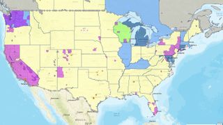
With various states and counties introducing different policies and restrictions, it can be hard to keep track of what is and isn’t allowed, but AAA (opens in new tab), which provides some of the best roadside assistance plans (opens in new tab) has stepped in to clarify. The new map shows travel related restrictions across the US and Canada. Using data from Johns Hopkins University, it also includes COVID-19 case count information by both county and state. Information displayed includes roadway travel checkpoints, where you may be stopped by officials to check your origin, destination and other key information. National land closures, such as national parks and monuments, have also been noted, and travel restrictions include citywide and nationwide guidance. The travel map also includes data on which regions have mask requirements, but it’s a good idea to have one on hand even if it isn’t mandatory. Check out our ultimate guide to face masks (opens in new tab) for more information on how to make your own.
Record low predicted for memorial day travel
The map can be viewed here (opens in new tab), and according to Fast Company (opens in new tab), is optimized for cell phone screens (just be sure not to check it while driving!). However, even if you can travel, this doesn’t necessarily mean you should. The AAA accepts that travel is a personal decision, but advises (opens in new tab) that travelers ‘should heed all official advisories, including the latest guidance from CDC and the State Department.’ The AAA has halted its annual Memorial Day travel projection, with Paula Twidale, senior vice president of AAA Travel, saying: “Last year, 43 million Americans traveled for Memorial Day Weekend – the second-highest travel volume on record since AAA began tracking holiday travel volumes in 2000. With social distancing guidelines still in practice, this holiday weekend’s travel volume is likely to set a record low.”
